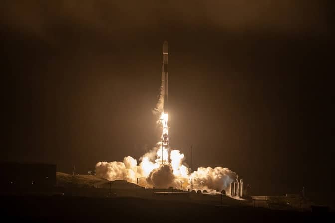
The first phase of the FireSat Constellation launched into low-Earth orbit in March, paving the way for a large constellation of satellites that will improve wildfire detection, monitoring and response around the world.
The project is led by Earth Fire Alliance, a community-led, non-profit coalition aligned to deliver transformative real-time data from all fires on Earth. It was developed in partnership with Muon Space, an end-to-end Space Systems Provider that designs, builds, and operates mission-tailored low-earth orbit (LEO) satellite constellations.
Built by Muon Space, FireSat builds upon the groundbreaking development of constellations of GNSS technology that have been operated at the University of Michigan ever since NASA’s CYGNSS mission launched in 2016.
The initial FireSat demonstration will feature three Muon Halo satellites equipped with state-of-the-art 6-band multispectral infrared (IR) instruments designed and optimized for the wildfire mission. It also utilizes Next-Generation GNSS (Global Navigation Satellite System) receiver technology, which was developed from designs licensed to Muon Space by researchers at the University of Michigan in collaboration with engineers in the Space Physics Research Laboratory.
Detecting Forest Fires from Space
Designed to capture fire characterization data across every stage of a fire’s lifecycle, the FireSat Constellation will give decision-makers and first responders near real-time insights, leading to more informed responses and better fire management practices. After the launch of the first three satellites, the FireSat Constellation will observe every point on Earth at least twice a day, with key wildfire-prone regions revisited more frequently.
“It’s a promising technology,” said Deputy Chief Marcus Hernandez, who leads the Office of Wildfire Technology Research and Development in California. “The FireSat initiative aims to provide greater situational awareness than we’ve ever had before.”
Over time, the project aims to use a total of 50 small satellites in low-Earth orbit that would yield more timely information on fire perimeters and greater fidelity, providing higher resolution of wildfire dynamics with nearly 100 percent coverage of Earth’s surface every 20 minutes.
“Our primary interest is fire perimeters, which will be updated much more often, with greater fidelity, and the rate of spread,” said Hernandez. “Situational awareness through fire perimeters is our key area or primary area of interest.”
Firefighters at the California Department of Forestry and Fire Protection, or CAL FIRE, said the new FireSat project represents the greatest advancement in fire-fighting technology for wildfires in this century.
“The FireSat constellation would be groundbreaking for us,” said Robert Clark, Assistant Chief of Predictive Services for CAL FIRE. “It can provide us real-time updates of where our fire is. A lot of times, when the fires are burning, the smoke columns obscure where the fire is at. We have limited aerial resources that could get us the information.”
Higher Fidelity Images, Greater Protection from Wildfires
After 25 years in the fire service, Clark has worked in areas ranging from mapping incidents of fires and serving as a planning section chief, to working as a fire behavior analyst.
“Typically, in wind-driven situations like the fires we had in L.A., the winds were so strong the aircraft couldn’t fly,” said Clark. “So, with the aircraft not flying, that means we’re not getting updated information of where our fire is at and when it would reach a certain point. So, having this remote-sensing product from the FireSat program that could provide us updated perimeters in a timely fashion, it can do both: It can inform the decision-makers, and it can prepare the public on those events.”
He said the results from FireSat would allow responders to plan for the movement of wildfires in the longer term. They would use fire progression data to track and analyze patterns, and compare the data with climatology conditions, weather and topography to better understand the wildfire environment and the effects of fuels standing in a fire’s path.
“That is a limiting factor that we have in the fire service and the wildland fire agencies,” said Clark. “There’s a lot of different folks in different agencies who are looking at it and trying to analyze it, but having a rapid refresh rate would lead to a greater data set for that analysis.”
The success of the effort depends on having fully funded programs and staff to support it. With the proper support, the data could be monitored and analyzed on a timely basis. Currently, such information has a lag time, with data taking three to seven days before it is analyzed and converted into a usable data product.
“We know there’s a lag time,” said Clark. “If we could get that down to less than 3 days. That that would be a great benefit. Hopefully, with new technology, new sensors, and new payload packages, we could get that data that covers the entire state in a in a more timely fashion.”
Using Remote Sensing to Combat Natural Disasters
The project to better detect and respond to wildfires is part of broader effort to advance our understanding of forest fires. It will demonstrate how remote-sensing data can be used to protect the public, and the extent to which contributing factors escalate fire dangers, ranging from ground fuel to variations in soil moisture. These are the types of science data products that the remote-sensing technology perfected through the CYGNSS mission can offer to help mitigate natural disasters.
Chris Ruf, a professor in the University of Michigan Department of Climate and Space who also serves as advisor to the board at Muon Space, said the CYGNSS mission has become invaluable in terms of its remote-sensing data products over time. Short for the Cyclone Global Navigation Satellite System, the mission was originally designed to better forecast the paths of cyclones and hurricanes.
“Using modern electronics, the Next-Generation GNSS Receiver evolved out of CYGNSS technology,” said Ruf.
The hardware was designed at University of Michigan, where researchers and engineers licensed the intellectual property to Muon Space to support the development of FireSat’s GNSS-R sensor.
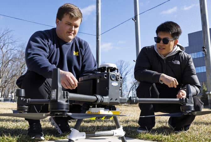
“We have a new version, which we’re calling the LGRx, which is a Lightweight GNSS Receiver,” said Ruf. “It has faster electronics. We made it way, way smaller and lower power, lower mass, so that we can put it on a small drone. We’ve got a whole bunch of plans for what we’re going to do with that when we start flying it, with a handful of different types of applications, including soil moisture and vegetation health.”
Beginning this spring, the drone carrying the new lightweight technology will be used in the Matthaei Botanical Gardens, to gather remote-sensing data on the amount of moisture in the soil and the amount of water in the leaves. Knowledge about wet or dry conditions can be beneficial to local horticulturalists, but it is also of interest to the firefighters responding to wildfires.
In a partnership between CAL FIRE and Muon Space, soil moisture sensors are being installed at Remote Automated Weather Stations across California in 2025. They are funded by a grant from NASA’s Science Mission Directorate in association with the CYGNSS program, with the goal of evaluating soil moisture data collected remotely to analyze dry conditions and risks of fire.
“The constellation already has promise for many things we’re interested in,” said Hernandez. “We’re very excited for the next year and a half.”
The project is led by the Earth Fire Alliance, a nonprofit that aims to tackle the global wildfire crisis. They are backed by Google, the Environmental Defense Fund, the Gordon and Betty Moore Foundation, the Minderoo Foundation and Muon Space.
Ruf has a financial interest in Muon Space.
The post New FireSat Set to Transform Wildfire Detection and Response appeared first on Climate and Space Sciences and Engineering.